Another day in the Cairngorms was too hard to pass up with mountains of holiday to take. I hatched a plan and Ronnie was up for it too. The plan was to set off at Kingussie and cycle though Glen Tromie, through the Gaick pass and down to Glen Garry to pick up the A9 cycle path / route 7 to get us back to Kingussie via the Dromochter Pass. Simples.

It’s a well trodden cycle route by all accounts but was new to me, I stumbled across it on the internet somehow and thought it would be a decent day out. As the route pops out near Blair Atholl it is possible to catch the train North to Kingussie instead of the cycle path. The way we did it made sense to get the tough off road section done sooner and leave an easy ride on cycle path to the latter. Because this is remote territory, we packed bags with food and emergency equipment (warm/ dry clothing, waterproofs etc)
It was raining all the way up the A9 from Edinburgh. Heavy claggy rain. Arriving in Kingussie we headed for Glen Tromie, if you’re not good with roads, there’s a decent off road cycle path to follow. We opted for the road though where huge puddles had formed from the rain. At a road bend, we turned right onto the track to Glen Tromie. This wide track ran for some way following the river Tromie to Gaick. We only passed 3 hikers at the start hiking out looking quite miserable. The rain had stopped by the time we’d reached the dam, and the track had turned to tarmac for a while. Soon after the road turned to track again and ahead Gaick Lodge. We stopped to eat something, staring at the hills surrounding us, contemplating how long it would take to reach the tops.

The going was good at this point, the steady climb wasn’t too noticeable and the track was well made. Horses roamed the fields around the lodge where soon after the first river crossing greeted us. The fording point was split with an island in the middle, thankfully the water was low but at spate it might have been more difficult to cross. My handling skills aren’t good and thanks to other blogs I was knowledgeable enough to know not to attempt the ride. The first part must have been about 30cm deep, with semi submerged boulders I was able to use the bike as a steady hold whilst walking through the river. My sealskinz waterproof socks were excellent and kept my feet dry. It’s good to have grippy shoes and I was using my trail shoes, Inov8 roclites.

I reached the island without much of a to do. The remaining section was lower and slower water which tempted me to ride it. And so I did with the pedals just reaching the water.
My first real river crossing on a bike felt good. My practice in running through rivers helped understand the current and better crossing points I imagine but when cycling it’s better to have dry feet than wet given how cold you can get when riding with wet feet.
From here the track turned right and entered a narrow Glen, and soon we would cross another few fords of smaller streams. A loch lay ahead, and we’d follow the track down and across its outflow, I opted to push down this wee section as the boulders seemed too large for my skills. The river was flowing fast and it appeared quite deep at the fording section, a scout up river seemed to be fruitless so we headed back to the fording point. Again, the waterproof socks proved to be outstanding and we were over in no time. River levels were at their lowest when I looked online at the Garry and Tromie suggesting that rainfall hasn’t produced much recently. In heavier rain times these rivers would become trickier and perhaps up to knees or thighs and you’d be concerned at that point.
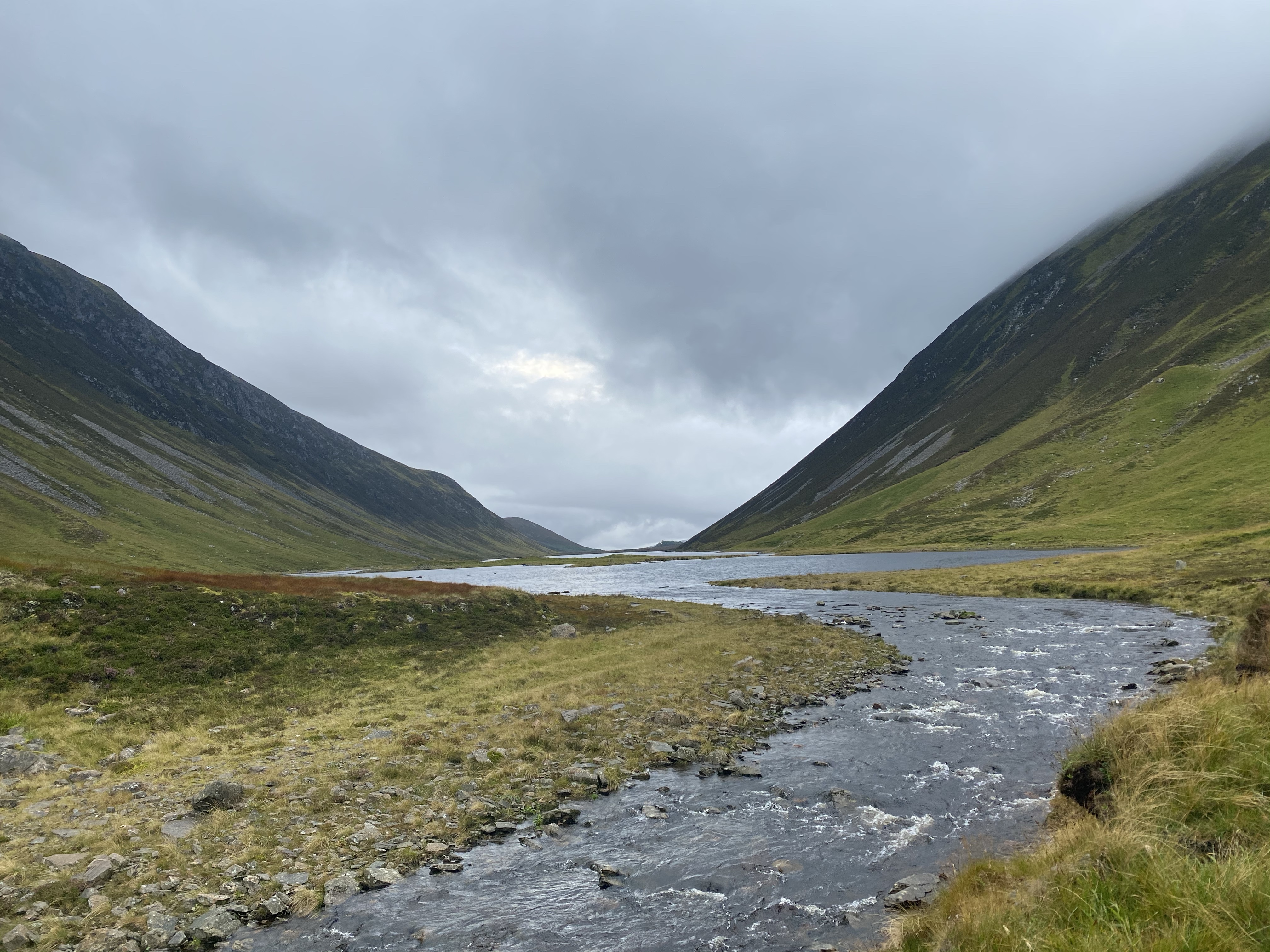
The track changed to a single track path, boggy in places and soon followed the side of the loch about 10m up the steep heather lagged bank. Rocks would jut out at angles and deep rooted bike tracks would tramline you into one direction. It proved hard for me to ride, though Ronnie gave it a good bash. It was easier for me to push and run with the bike so I did. The fear of a fall down the bank was too great for me to ride it. Except Ronnie did and Ronnie did stack it head over heals down it, grabbing onto the heather to prevent a damp landing. I was oblivious to this and caught up with him climbing back up. It could have been nasty out there, zero signal and we’d seen no one for hours. So remember to take all safety stuff as accidents can happen.

The single track was expected and it didn’t last too long. We saw two eagles above us as we slowly made our way south.
I’d read that the path fords the river coming Cama Chorie and then fords again across a culvert and that it was better to stay dry and follow a track diagonal towards the lodge you can see. So we did. And it was boggy. Most unridable and some bits of bog where you lose your wheel in it.
We found the path down to the track and looking back the fording point was low and the 2nd across the culvert was barely flowing through it so we’d have been better taking the non boggy section. But you do learn and if I ever come back I will know for next time.

Eating 2nd lunch here, legs dangling from the culvert with the sun on our backs it was quite pleasant knowing the hard section was behind us. From here the decent double track heads south and downhill. We made good progress toward the A9, passing some people eventually in a Land Rover and some sheep too. The valley here was wide with views toward Rannoch Moor.

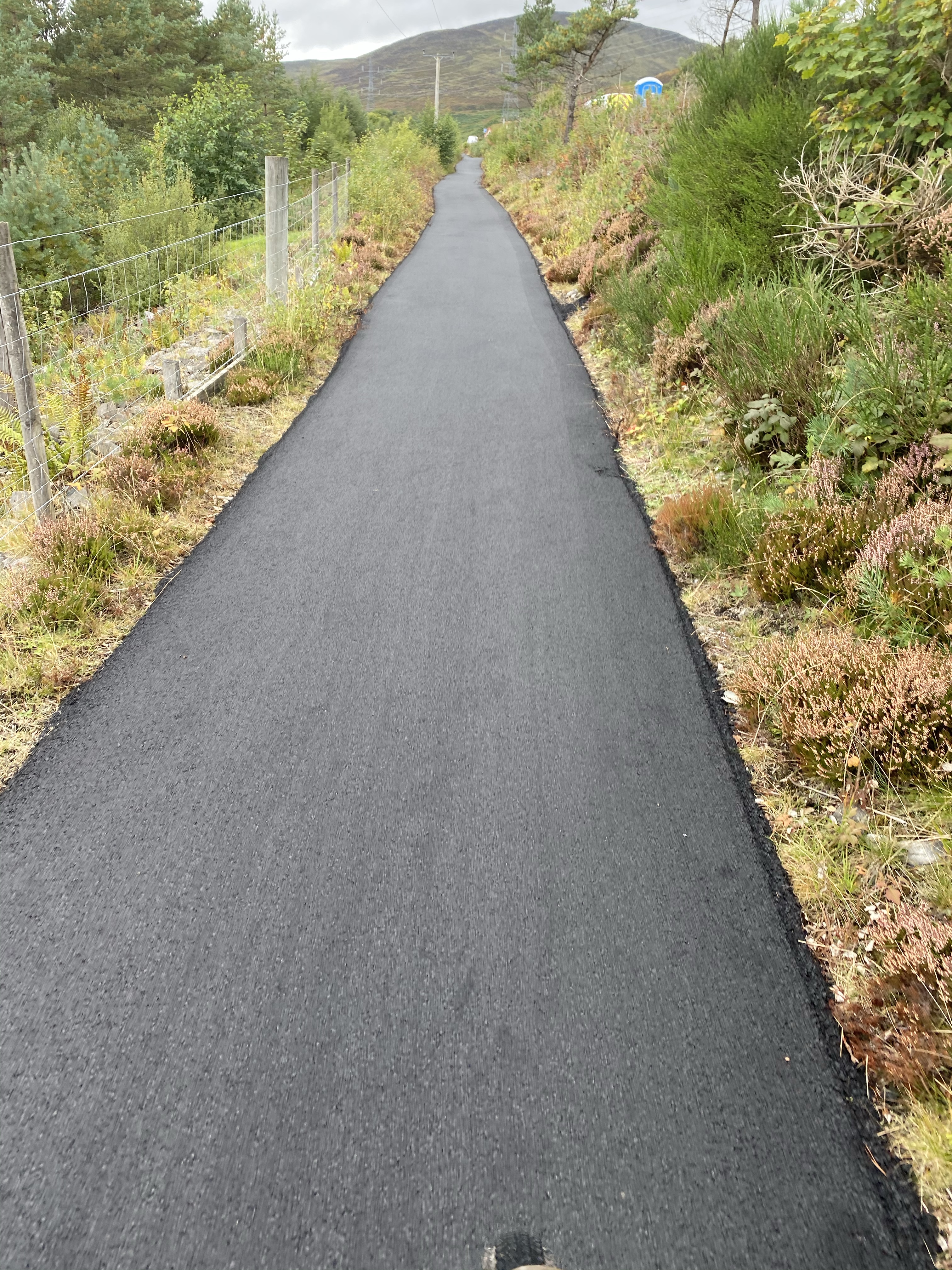
A short uphill leads you to a mast and then into a plantation to reach the A9 where a crossing point across the dual carriageway helps you navigate fast traffic. The cycle path is well signed here and was freshly tarmac’d as we spun out smoothly North. Following the road I thought this wouldn’t be that good but the views were decent enough and the traffic wasn’t too bad. Sections of Route 7 follows the old A9 before it was redirected to its new course, and other sections follows the embankment of the road squashed between the river and the railway on the other side.
The path goes uphill to the Dromochter Pass before starting downhill on its way to Dalwhinnie where we stopped for refreshments at the service station and then heads north along a B road to final reach the last A9 section to Newtonmore. This last A9 section was mainly through trees shading us from the sun. The wind was at our backs and we freewheeled for quite a bit of it which was needed after 40odd miles in the saddle.
The section to Kingussie via Newtonmore was on the road though an off road path started just at the end of Newtonmore.
85kms at the end finished off with a chippy and Ronnies longest ride and my longest on a mountain bike. We both got in our separate cars (covid rules) to head home after a grand day out.

